
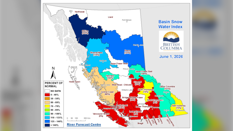
The Peace Region is bucking a provincial trend as snowpack levels across the rest of British Columbia are sitting well below normal heading into summer.
A report from the B.C. River Forecast Centre shows the province’s overall snowpack at 64 per cent of normal as of June 1, following a warm and dry May that accelerated melting across much of the province.
However, the Peace Region remains an exception. Snowpack levels in the Peace basin are measured at 137 per cent of normal, among the highest in B.C. and well above last year’s levels.
Warm spring speeds up melt
The report points to above-normal temperatures and below-normal precipitation through May as the key drivers behind the rapid melt seen across southern and central parts of the province.
By early June, about two-thirds of the seasonal snowpack had already melted, compared to a typical average of around 55 per cent for this time of year.
That trend has left several regions, including Vancouver Island and parts of the southern Interior with extremely low snowpack levels.
Peace Region holds higher risk for runoff
In contrast, northern areas like the Peace Region are holding onto more snow, particularly at higher elevations.
Forecasters say that could mean a longer and more gradual spring runoff period, with continued potential for elevated river levels into late June and early July.
The Peace Region is among several northern basins, including the Upper Fraser and Skeena-Nass where above-normal snowpack could increase the risk of higher streamflows or localized flooding, especially if combined with heavy rainfall or sustained warm temperatures.
Drought concerns still dominate elsewhere
While the Peace Region and other northern areas may see higher runoff, the broader provincial picture remains concerning.
Officials say drought risk is highest in southern B.C., where early snowmelt and a lack of precipitation have already reduced water supplies heading into summer.
Seasonal forecasts also point toward a greater likelihood of above-normal temperatures across much of the province through the summer, which could further strain water resources if dry conditions persist.
What it means locally
For northeastern B.C., the outlook is mixed. A higher snowpack could help sustain river flows longer into the summer. But it also means monitoring for fluctuating water levels and potential runoff impacts in the coming weeks.
The River Forecast Centre says flood risk will depend not just on snowpack, but on how quickly temperatures rise and whether significant rainfall events develop.